Friday, October 27, 2006

Panamint City


This weren’t no walk in the park!

Wasn’t even like a walk around Fort Bragg!

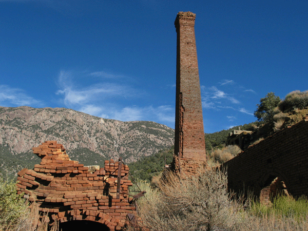
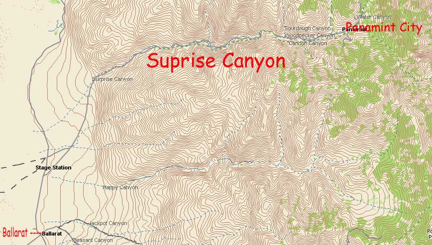
My goal was the ghost town of Panamint City in the mountains west of Death Valley.

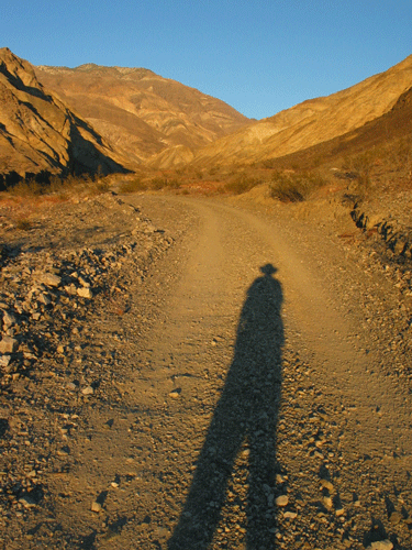
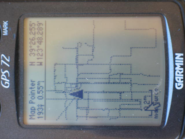
It is only a five and a half mile hike from the trailhead but it took me eight and a half hours to get up there!!

The starting elevation is 2,249 ft. and the finish, 6,346 ft. I had to scramble up a couple waterfalls and then struggle through two miles of brush.

My feet held up just fine because of all the walking I have been doing but my back and hips were not used to the weight of the backpack I carried.

Fortunately, there is a nice cabin complete with running water. I stayed three nights. The weather was perfect; 60 degrees during the day, 40 at night.

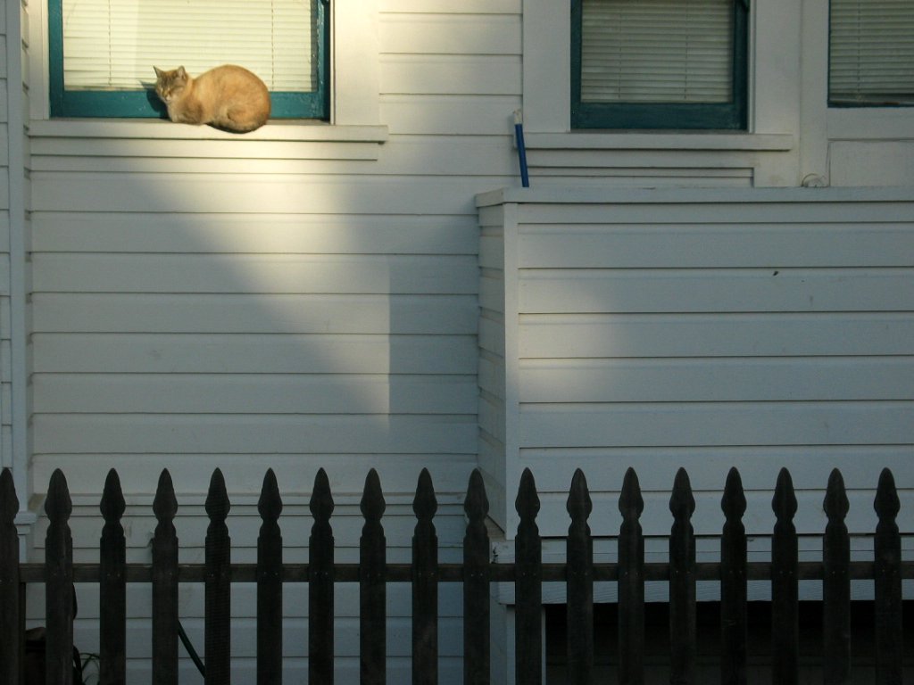
I saw burros, Ravens, chipmunks, Juncos, Goldfinches, one hawk and recent scat from Coyote. At night I heard, but never saw, the resident packrat.

Nor did I see a single person or speak a single word.

I explored the mining ruins and the various canyons during the day. Evenings I read the log book entries by previous visitors and a 1978 National Geographic.

No cell phone, no Wi-Fi, no lights, electricity, traffic or noise except the occasional wind in the Juniper and pine. Wonderful!
.
It took five and a half hours to hike down.

In a few more days I will drive six hundred miles home and be walking the Easy Streets of Fort Bragg once again.

Saturday, October 21, 2006

Surprise Canyon


This is it! The road less traveled!

Friday I found a place to park my VW beside the Surprise Canyon road and set up camp.

In the evening I hiked one and a half miles up the road and back. I have been concerned about the relentless elevation gain but returned to camp feeling refreshed.

This morning I hiked two miles up and back only this time I wore my old Kelty backpack loaded with various things as dead weight. I got to breathing pretty good and my heart rate up but stopping to take photographs now and then helps!!

During my walk I saw fresh coyote scat but I never heard them sing during the night. My friends the Ravens are here. I holler at them and they will interrupt where they are going and come take a look at me!!

Now I am back in camp looking out over the vast Panamint Valley. One car went by yesterday. Two this morning.

Pretty quiet around here!

Monday I will hike up to Panamint City. I plan to stay several days.

Friday, October 20, 2006

Mojave

It took ten hours of driving to get to this area just east of the town of Mojave. I set up my camp, cleaned up the mess from previous campers; beer cans and shot gun shells. But they did leave a nice small pile of firewood which I enjoyed when it got dark. I heard an owl and saw a bat.

This morning I did a short walk through the sagebrush enjoying the early morning bird song. I heard, but not see, quail. There were other small birds, gray with long curved beaks, (I’ll look then up later), flitting around in the Joshua trees.

But I still had it in my mind walking Boron and Trona.

When I arrived in Boron I changed my mind. Pretty rough neighborhoods and lots of dogs.

When I arrived in Trona I changed my mind again thinking I rather walk amongst the beauty of the desert.

This evening I will do just that.

Thursday, October 19, 2006

Hitting the road


I’m leaving for the desert this morning. I will be gone approximately two weeks. I plan to spend the night of October 21 in the former town of Ballarat which is located in the Panamint Valley just west of Death Valley. Some of us desert rats are gathering for the Orionid Meteor Shower.

The following week I want to try walking up to Panamint City located high in the Panamint mountains. It is only a six mile walk from the trailhead but I expect it will take me about seven hours because of the 3,600 foot elevation gain! Therefore I plan on taking my old Kelty backpack and staying overnight.

If I have enough steam left I am also thinking about walking the streets of Shoshone, Boron and maybe Trona! All are sprinkled around Death Valley.

The 27th through the 29th there is a gathering of the friends of PanamintCharlie.com at the Panamint Springs Resort. After that I will start heading for home.

There is Wi-Fi at PSR so maybe I will be able to update this blog a time or two while out in the vast wilderness.

Wednesday, October 18, 2006

Bridges

This morning I walked to North Harbor Drive, down through the harbor, under the recently replaced Noyo Bridge, up the closed road behind the “Too Tall Motel” and home. A walk of just under four miles.
This photo was taken May 22nd.


Speaking of bridges….

The next photo is of the Pudding Creek Trestle.

This was originally a railroad bridge for bring logs to the Union Lumber Company from Ten Mile.


When logging trucks became more economical the tracks were removed and the haul route paved with black-top.

Then the Company closed and the Pudding Creek Bridge fell into disrepair and was eventually blocked off because of safety concerns. The abandoned haul road to Ten Mile became a popular hiking trail.

Now the Pudding Creek Bridge is being repaired and when it re-opens it will make access from Fort Bragg to the coastal “Haul Road”hiking trail much easier.


On this map you can see Pudding Creek, the trestle bridge location west of Highway One and the old haul road north towards Ten Mile.

Bottom photo.

Also in the works is a complete hiking trail around the headland of the former lumber mill which is the whole ocean side of Fort Bragg! I added the red line to show the eastern boundry of the company property.

That area has always been closed to hikers and walkers, joggers and bicyclists. With the mill closed the city is figuring out how to develop that area.

High on the list is a public trail along the headland.

Fort Bragg is becoming a great place to walk.

Tuesday, October 17, 2006

Mixed feelings

On Main Street by the Guest House Museum is this slice of Redwood. The information plaques mounted on it are in the lower photos.

The following are excerpts from “Fort Bragg Remembered, a 1989 Centennial Oral History”.

“…. The biggest tree ever took down? That big one down in front of Company Headquarters. These guys I’m telling you about was the ones that fell that tree. And I remember when they fell it because we didn’t pay no attention to stuff like that, we went right by it every day. It was in a terrible bad place. They had to take a bulldozer and as much as they could save of that tree was 100 feet. but they got 100,000 feet of timber out of it. If they could have saved the whole tree they really wound have had 150,000 feet.

Just another’s day work in those days. But I think back, it was something we should have paid a little more attention to. Those fellas were using a drag saw to fall that, you couldn’t work a tree that big with a chain saw. No way. The longest blade they had was a twelve-foot, so they had these two twelve-footers welded together. They brought it up on the (railroad) flat car. It took three guys to carry it.

When they fell that tree they wanted that piece for down there and they sawed that piece off and then they split it. That’s put together down there. It wasn’t in one piece.”


Monday, October 16, 2006

My alarm clock

Here is a photo of my alarm clock. It is the timer for our garden watering system. A while back I noticed I could hear the water pipes “sing” for a moment when the timer turned on. Like when someone flushes the toilet or loo.

I decided to set it to turn on at 5:45 AM so I would be up and out the door by 6:00. It is quiet enough Lolli doesn't notice but it works for me!

This morning I did what has become my basic walk. North to Winifred, east to Howard, south to Maple and back home on Franklin. 3.3 miles in one hour. I really enjoy the zen of walking in the dark with negligible traffic but there isn’t much to see or photograph. Daylight savings going off at the end of this month might brighten things up for a while. During my walk I stopped in at Safeway to pick up a can of refried beans for our evening tacos.

Speaking of Safeway, I am currently reading “Fort Bragg Remembered. A Centennial Oral History” published in 1989. I’m learning more about what I see during my walks. One old timer in the book said; “Little by little this road (Franklin, south of Madrone) came through. It was closed before because it was a swamp. Where Safeway is now, this was all swamp. There was no street open. They cleaned the swamp up and they fill it up, a lot of dirt, so it is all nice and clear.”

She doesn’t mention when this occurred but I have just started reading this book, loaned to me by Valerie.

Another part of my basic morning routine is checking the APOD. Today's photo is stunning.

http://antwrp.gsfc.nasa.gov/apod/ap061016.html

Saturday, October 14, 2006

Amateur


Last evening Lolli and I were talking about my decision to take up walking and blogging. She said “You are an amateur”. I thought that was rather derogatory compared to what I held in my mind but then she said, “Look it up, I’m talking about the first definition.”

I pulled out The Random House College Dictionary.

“Amateur 1. a person who engages in an activity for pleasure rather than for financial benefit.”

Well hey! Thanks Lolli! That be me!

Case in point.

Even though it is Saturday and I usually don’t walk on weekends I decided to walk a little sub-division that had grabbed my attention on the map. Most of the blocks in Fort Bragg are rather standard, whatever that means, but this area consists of “standard” length blocks north and south but half width blocks east and west.

I walked to the corner of Harold and Oak and then set about circumnavigating the whole section of interest and then did the back and forth on the north/south streets. All told it was just under three miles. I feel better and noticed no financial benefit! Perfect!

Friday, October 13, 2006

Morning Musings


Six AM and I’m out the door. Sometimes the sound of pounding surf draws me to Glass Beach and screaming seagulls but this morning is cool and damp with the sound of the Noyo foghorn in the distance, perfect for a walk up Whipple, east on Winifred, south on Brandon, Cory and Grove.

This time of year the yellow streetlights wink out, one by one, as the marine layer begins to brighten. Rays the color of forest fire begin peeking between the coastal hills.

Occasionally I encounter wood smoke and further on, someone’s morning toke lingers in the air. Ravens glide silently onto the soccer field. A school bus rattles by, stops at Oak, blinks and turns right. Diesel fumes dissipate.

Blue light flickers on drawn curtains; the morning news in progress. Through an open window I hear someone snoring, then a dog barks.

Thursday, October 12, 2006

The Fort Bragg Obelisk?

I really like the routine I have developed of waking up at 5:45 and out the door at 6:00. I generally walk for a little over an hour at 3.3 mph and return home looking forward to brewing my cup of green tea and checking my e-mail. My brother in Kirkland, Washington is three years younger than I and still a working stiff. He arrives at work at 5:00 AM! So, each morning I have an e-mail waiting from him and I respond. We have had this "back and forth" going for almost four years! Then, fifteen minutes before my wife wants to wake up, usually 8:00 or 8:30 depending on her teaching schedule, I make our Oatmeal and a steaming latte for her. Then it is time to compose my Walking Fort Bragg blog.

It is really nice being Mr. Retired Guy!

Because it is dark durning my morning walk now I find I am starting to do additional walks during the day to photograph various oddities for this blog. My friend Eddie gave me another assignment and I went looking for it yesterday afternoon.

By Golly, it was located only two blocks from our apartment and I had never noticed it before! It is on the south/east corner of Fir and McPherson. As you can see it is dated 1936. I have no idea what it was about and will add it to my list of questions for the folks at the Fort Bragg Museum.
Speaking of the Fort Bragg Museum, I stopped in the other day and looked around. I was given the names of a few people that may be able to answer some of my questions.

Square Telephone poles?

Obelisk?

Wednesday, October 11, 2006

Another square pole


The first square pole I discovered during an earlier walk is located at the south/west corner of Laurel and Harrison. It is quite old and possibly one of the original poles! I think it is made of redwood and was probably milled right here in Fort Bragg. I mentioned my discovery of a square telephone pole to my friend Eddie and he said there is another one on Harold. So that was my plan this morning, find that pole.


I made my way to the north end of Harold and started south. Some of the telephone and power poles were far enough away from street lights that I had to walk over and feel them to "see" if they were round or square. All were round until, Bingo, the pole on the west side of Harold, just south of Laurel, was SQUARE!


I returned at 10:00 AM with my camera to document it.


That makes it Two Square Poles and Five Tie-Down Rings, so far!

Tuesday, October 10, 2006

Walking Franklin


Folks are putting up their decorations for Halloween. One house on Franklin in particular really puts on a show. The old two story house is already creepy enough the rest of the year what with the perpetually closed drapes, peeling paint, sagging porch and lots of house cats sitting in the various windows. Now this! <---

By the way, I discovered why there were no garbage trucks and morning paper delivery during my six o'clock walk yesterday. Around noon I walked to the Post Office to drop off a letter and it was closed, I figured they must be out to lunch. I continued on to my bank and it was also closed but at least it had a sign in the window, "Closed for Columbus Day".

Ding!

But back to the purpose of my walk this morning. I wanted to walk the length of Franklin Street which is bounded on the north by Pudding Creek and on the south by Noyo Harbor. Franklin Street is only 1.8 miles long and straight as a string from Manzanita to Cypress.

Fort Bragg was a lumber town, therefore the majority of the east/west streets are named after trees but one street, for some reason, was not named after a tree and I will highlight it in the following list. Maybe it was a joke.

Okay, from north to south; Manzanita - Elm - Spruce - Bush - Fir - Pine - Laurel - Redwood - Alder - Oak - Madrone - Maple - Hazel - Chestnut - Walnut - Cypress.

South of Cypress Franklin swerves a little, is crossed by South Street and finally ends at North Harbor Drive. North Harbor Drive used to be Highway One. Why one street crossing Franklin is named South Street I have no idea. There is a lot of history I have to learn and walking the streets of Fort Bragg brings interesting questions to mind. I've got my work cut out for me!

Monday, October 9, 2006

Maps?


I have been looking at the run/brooklyn blog and wondering how he captured the map he posts at the top of each blog.

Each time I would "click to save" the map route I generated in GMap-Pedometer I would be taken to the host site with no option to save my map.

So, I spent about an hour this morning looking around and checking the FAQs and Forums at the GMap-Pedometer site.

In the forums I found one guy who wrote he captures the map image by using "alt-PrintScr", then pasting the image in Paint. He then copies the portion he wants and saves it as a bmp.

I used his suggestion but then used my PhotoShop to finish resizing the map and converted it to a .jpg via WebReady. Whew!

Anybody got a easier way?

By the way, the map shows my walk of 5.2 miles the day I started this Blog, October 6th, 2006.

Monday Monday


I spotted this sign last Friday but didn't have my camera with me. All weekend I kept hoping the wording would not be changed before I got a chance to photograph it. Sure enough, when I came around the corner from Dana unto Chestnut I could see it off in the distance but I could not tell if the words were the same until I got closer. The message was the same. Perfect!

I could also see Orion was almost straight up in the southern sky. Personally, I have more faith in Orion.

At the east end of Laurel, near Otis Johnson Park, the school buses were being warmed up and checked out at the bus barn before their morning runs. Other than that, it was a very quiet morning. No garbage trucks banging around and I didn't see the paper delivery guy driving around. I was walking at my usual time but they weren't about their business at their usual time.


I only saw one fellow walker and we exchanged the usual "Good Morning" as we passed in opposite directions on Franklin. There is another early bird I usually meet on Harold but he has gone missing again. I saw him quite often during the summer and then he disappeared. When I saw him again last week I hollered over at him, "I've missed you!". He replied, "Been fishing in Colorado." The next morning I was going to follow up with the question, "Catch any?" but I have not seen him again.


Since I had my camera with me I stopped and documented one of the horse and buggy tie-down rings I discovered last week at the south-east corner of Redwood and McPherson. Because it is located in a handicap zone of course it is painted blue!

Sunday, October 8, 2006

Walking around Lake Cleone


Last evening we camped at the Mac Kerricher State Park campground three miles north of Fort Bragg. Just a quick little overnight camp-out with our friends Ed and Suzanne in our two Vanagon campers.

In the evening after our barbequed chicken dinner, sitting around the campfire, the local camp robber showed up and ran off with the chicken bones.

But now we get to the walking part. Our friends are "birders" so this morning we got up early and walked the .628 mile trail around Lake Cleone. Here is the list of what we saw:
Brown Pelican
Heerman’s Gull
Greater Scaup
Ring Neck Duck
Wood Duck (beautiful)
American Coot
American Widgeon
Greater White Fronted Geese
Ruddy Duck
Pie-billed Grebe
Eared Grebe
Black Phoebe
Fox Sparrow
Winter Wren
Acorn Woodpeckers
Yellow Rump Warblers
Some kind of Flycatcher
Ravens
Stellar Jays
Chickadees
Song Spparrows
Northern Flicker

Saturday, October 7, 2006

GPS


I am using an inexpensive Garmin GPS to keep track of my walk. As you can see the GPS records my walks by leaving a trail of "cookie crumbs". It also has what is called a "Trip Computer" that has a "Trip Odometer", plus it records my average and overall miles per hour and it records stopped, moving and total time during my walk. The photo of the GPS shows accumulated walks from several weeks.

Pretty cool!

I was wondering where I should carry it so it would have a good view of the satellites. I didn't want to carry it in my hand all the time. I was thinking of sewing on a pocket high up on my sleeve but then I realized I usually wear a hooded sweatshirt but don't use the hood. Bingo! I carry the GPS in the "pouch" the hood makes behind my head. Perfect!

Friday, October 6, 2006

Taking photos


Last summer, during my morning walks, I accumulated a bunch of photos of cats, dogs, architecture, bumper stickers. Oddities. Now that it is dark during my walk I will post some of the photos from those walks.

This photo is of an older house and its river rock wall but the most interesting thing is the tie-down ring in the curb; left from the horse and buggy days!

So far, in my walks, I have discovered five of these rings. I'm surprised they have not been ground off flush because now a day they might be considered a tripping hazard. Myself, I'm glad they still exist.


Here is an electric car I discovered May 12Th during a beautiful morning sunrise. Since then it has not moved. The ultimate economy car!

Walking Fort Bragg, California


I started walking the streets of Fort Bragg, California about six months ago but just recently discovered blogs of other people walking the streets of their city or town or in one case, county! And, as reading blogs go, one thing leads to another....


First I "ran" across Walking Berkeley that lead to RunBrooklynRun and that lead me to GMap Pedometer. Then I discovered WalkingAbout.


In WalkingAbout I got some ideas about improving stride and arm motion and gave it a try this morning. It felt good and I walked 5.2 miles in an hour and a half!


Like I said, I started walking six months ago. I am 65 years old and my weight was getting up around 186. I don't mind being old but I don't like being heavy. Getting off my butt and out the door was my desire but I just never seemed to get around to it. One day I mentioned my desire to my friend Suzanne and she said her husband gets up and goes walking first thing in the morning. "Before breakfast or anything. Just gets up and goes!"


The next morning I gave it a try. And by golly, this concept fits me to a tee!

When I started walking it was sunny in the morning at 6:00 AM. My wife and I had recently moved to Fort Bragg and I realized walking would be a great way to get to know this town so I basically just meandered the streets of Fort Bragg with my camera in hand and took photos of the different architecture, cats and dogs.


That kept my interest for quite a while but gradually the seasons move on and each morning at 6:00 AM was a bit darker. Now, it is totally dark during my morning walk. But I like it.


The reason I like leaving at 6:00 AM is because there is very little traffic whereas by 7:00 AM the folks leaving for work are zooming through town and I end up waiting at cross streets now and then. At 6:00 AM there is only the guy delivering the morning paper and the garbage trucks!


Two days ago was the first time it was raining when I got up but it was a light rain and I went for it. The rain stopped by the time I got back home around 7:00 AM. It is rather unusual to have rain this early in this part of the country but it got me to thinking about what I will wear when the rainy season really does arrive.